


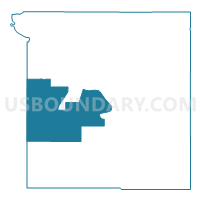
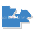
Voting District 30, Ottawa County, Oklahoma
About
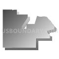
Outline

Summary
| Unique Area Identifier | 654919 |
| Name | Voting District 30 |
| County | Ottawa County |
| State | Oklahoma |
| Area (square miles) | 61.13 |
| Land Area (square miles) | 60.54 |
| Water Area (square miles) | 0.60 |
| % of Land Area | 99.02 |
| % of Water Area | 0.98 |
| Latitude of the Internal Point | 36.80830550 |
| Longtitude of the Internal Point | -94.91810800 |
Maps


Graphs
Select a template below for downloading or customizing gragh for Voting District 30, Ottawa County, Oklahoma


Neighbors
Neighoring Voting District (by Name) Neighboring Voting District on the Map
- Voting District 140, Craig County, OK
- Voting District 28, Ottawa County, OK
- Voting District 31, Ottawa County, OK
- Voting District 34, Ottawa County, OK
- Voting District 410, Craig County, OK
- Voting District 7, Ottawa County, OK
- Voting District 714, Craig County, OK
- Voting District 9, Ottawa County, OK
Top 10 Neighboring County Subdivision (by Population) Neighboring County Subdivision on the Map
- Miami CCD, Ottawa County, OK (20,133)
- Afton-Fairland CCD, Ottawa County, OK (4,311)
- North Craig CCD, Craig County, OK (3,061)
Top 10 Neighboring Place (by Population) Neighboring Place on the Map
Top 10 Neighboring Unified School District (by Population) Neighboring Unified School District on the Map
- Miami Public Schools, OK (15,278)
- Wyandotte Public Schools, OK (4,121)
- Fairland Public Schools, OK (3,114)
- Afton Public Schools, OK (2,827)
- Welch Public Schools, OK (1,882)
- Bluejacket Public Schools, OK (1,531)
Top 10 Neighboring State Legislative District Lower Chamber (by Population) Neighboring State Legislative District Lower Chamber on the Map
Top 10 Neighboring State Legislative District Upper Chamber (by Population) Neighboring State Legislative District Upper Chamber on the Map
Top 10 Neighboring 111th Congressional District (by Population) Neighboring 111th Congressional District on the Map
Top 10 Neighboring Census Tract (by Population) Neighboring Census Tract on the Map
- Census Tract 5747, Ottawa County, OK (4,573)
- Census Tract 5746, Ottawa County, OK (4,362)
- Census Tract 5748, Ottawa County, OK (4,311)
- Census Tract 3731, Craig County, OK (3,061)